
As we move further into winter, the weather across Illinois and Wisconsin is taking a significant turn. After surviving some of the coldest temperatures of the season with several days of subzero cold and wind chills as low as -20 to -30 degrees, residents are finally getting a much-needed break with temperatures in the 40s and 50s. However, as the month of February kicks off, another weather system is on the horizon, bringing the potential for another major snowstorm to the region.
A Brief Respite from the Cold
While the coldest temperatures of the season may have already passed, the residents of Illinois and Wisconsin are far from in the clear. Last week, frigid weather led to school closures, hazardous travel conditions, and power outages as temperatures dipped well below freezing and the wind chill factor made it feel much colder. These extreme conditions left many questioning how much more winter could the state endure.
Fortunately, the first days of February are providing a much-needed reprieve, with temperatures hovering in the mid-40s to lower 50s for most of the week. On January 30, temperatures peaked in the mid-50s, with slightly cooler weather in the 40s expected on January 31. As February 1 arrived, temperatures dipped into the 30s, and the forecast showed highs in the upper 30s for the start of the month. Despite the brief warm-up, the cold is far from over, and the upcoming storm is set to remind Illinoisans and Wisconsinites that winter is still in full force.
Winter Storm Coming: Up to 6 Inches Expected
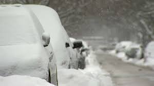
The biggest news is the possibility of a major snowstorm expected to impact both Illinois and Wisconsin. The storm is projected to begin mid-week, with snow starting to accumulate as early as the evening of Wednesday, February 5. According to the latest Weather Channel predictions, areas such as Rockford, Illinois, and much of Chicagoland could experience anywhere from 1 to 3 inches of snow by the end of the day on Wednesday. For some parts of the state, the snowfall will continue into Thursday, February 6, bringing additional snow accumulation and potential disruptions.

The forecast indicates a 40 percent chance of snow on Thursday, which could lead to another 2 to 3 inches of snow by the evening, pushing the total snowfall to up to 6 inches by Thursday night. This upcoming storm could cause considerable travel delays, especially along I-90, I-80, and other major highways in Illinois and Wisconsin. With snow expected to fall quickly over a short period of time, road conditions could deteriorate rapidly, making it difficult for drivers to navigate.
What’s Causing the Storm?
Meteorologists are currently monitoring several factors contributing to this weather system, with some computer models indicating that this could be the start of multiple winter storms. Some forecasts predict a combination of heavy rain and snow, especially for northern Illinois and southern Wisconsin. This mix of precipitation could make driving particularly dangerous, especially when temperatures drop below freezing, turning rain into ice.
While the models are still subject to change, it’s clear that residents of Illinois and Wisconsin should be prepared for significant winter weather over the next week. The snowstorm could cause hazardous conditions for commuters and lead to cancellations of events and disruptions in daily life.
Why More Snow Is Likely
The heavy snow and potential accumulation are linked to the shifting weather patterns and a colder, more active atmospheric system that is moving across the central United States. While the region has seen some milder conditions in recent days, the jet stream will push cold air back into the region, combining with moisture from the Gulf of Mexico to create the snowstorm.

As we enter the first full week of February, winter in Illinois and Wisconsin remains unpredictable, with more winter systems potentially forming as we move into the latter half of the season. According to meteorologists, this is a period where weather patterns are likely to become more active, with the possibility of another round of severe cold in the coming weeks.
What to Expect
The Weather Channel forecast for Rockford, Illinois, and the greater Chicagoland area shows a series of snow showers that will intensify through the week. According to experts, areas along the I-90 corridor will be particularly affected, with winds gusting up to 20 mph, making conditions feel even colder than they already are. As snow accumulates, road crews will be working to treat major highways, though travelers should be prepared for delays and be cautious while driving.
While it’s difficult to predict with 100% accuracy where the heaviest snow will fall, current predictions suggest that northern Illinois will bear the brunt of the snowstorm. Communities closer to the Wisconsin border are most likely to experience the highest snow accumulation, which could reach up to 6 inches or more. While southern Illinois may see lesser snowfall, there will still be significant impacts throughout the region, particularly in rural areas where roads may not be as well-maintained.
Preparing for the Storm
Residents in Illinois and Wisconsin should take the following precautions as the snowstorm approaches:

- Check Weather Forecasts Regularly: Since weather predictions can change quickly, it’s important to stay updated on the latest forecasts. Pay attention to winter storm warnings and advisories issued by local meteorologists.
- Prepare Your Vehicle: If you plan to drive during the storm, ensure your car is winter-ready with snow tires, windshield washer fluid, and an emergency kit in case you get stuck.
- Stay Safe on the Roads: If you don’t need to travel, avoid driving during the snowstorm. If you must travel, keep a safe distance from other vehicles, and drive slowly to avoid accidents.
- Stock Up on Essentials: With snowstorms sometimes leading to power outages, make sure you have enough food, water, medications, and blankets in case you are confined to your home.
- Monitor Local News: Follow updates from local news stations and government agencies to stay informed about road closures, school cancellations, and other important information.
Conclusion
While Illinois and Wisconsin are seeing a brief warm spell, winter is far from over, and the forecast predicts a significant snowstorm next week. With up to 6 inches of snow expected to accumulate over several days, the storm will bring hazardous conditions that could disrupt daily life. Be sure to take the necessary precautions to stay safe, whether you’re at home or on the road. Keep an eye on weather updates for the latest changes, as meteorologists continue to monitor this evolving weather system.
Disclaimer – Our editorial team has thoroughly fact-checked this article to ensure its accuracy and eliminate any potential misinformation. We are dedicated to upholding the highest standards of integrity in our content.
More Stories
Massive Snowstorm to Impact Illinois and Wisconsin Next Week
Massive Snowstorm to Impact Illinois and Wisconsin Next Week
Massive Snowstorm to Impact Illinois and Wisconsin Next Week