
Severe Winter Weather Expected Across Multiple States
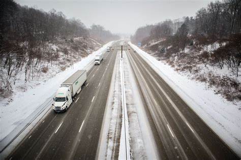
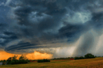
A powerful winter storm is making its way from the Midwest to the Northeast, bringing a significant threat of ice accumulation and dangerous travel conditions. Ice Storm Warnings have been issued for several areas as meteorologists predict freezing rain, sleet, and snow from Wednesday into Thursday. The storm is expected to impact major cities, leading to hazardous road conditions, power outages, and travel disruptions.
Affected Areas and Major Cities
The storm system is projected to affect several major metropolitan areas, including:
- Chicago, IL
- Des Moines, IA
- Baltimore, MD
- Washington, D.C.
- Philadelphia, PA
- Pittsburgh, PA
- Hartford, CT
- Boston, MA
Winter weather alerts have been issued from Wichita, Kansas, to Chicago, Illinois, with additional Ice Storm Warnings in place for regions in the Northeast. Cumberland, Maryland, is currently under an Ice Storm Warning, while Boston, Massachusetts, is under a Winter Weather Advisory. The Appalachians, northern Virginia, Maryland, and central Pennsylvania are also at risk for significant ice accumulation.
Weather Conditions and Expected Impacts
The storm system is driven by low-pressure movement, which is pulling in a large amount of moisture into areas with cold high pressure. This mix of conditions will result in various types of winter precipitation, including:
- Freezing Rain: The most concerning element of the storm, as ice accumulation can lead to dangerous road conditions, power outages, and fallen tree limbs.
- Sleet and Snow: While not the primary concern, some areas could see over three inches of snowfall, especially in higher elevations.
- Strong Winds: The combination of ice and strong winds increases the risk of power lines and tree branches breaking, leading to outages and damage.
Timing of the Storm
The storm began affecting portions of the Midwest early Wednesday morning, particularly around the Kansas City metro area, where freezing rain was already creating slick road conditions. As the storm continues to move eastward, freezing rain and sleet will impact parts of Iowa, Illinois, and Indiana throughout Wednesday.
By late Wednesday night into early Thursday, the most significant ice accumulation is expected to occur across the Mid-Atlantic states, including parts of the Delmarva Peninsula. Meteorologists warn that areas receiving the highest ice totals could face widespread power outages and road closures. Even a thin layer of ice can make roads dangerously slippery, leading to potential accidents and delays.
Fortunately, as the system progresses, warmer air is expected to move in, helping to alleviate some of the wintry conditions. However, travelers are advised to remain cautious as melting ice can still pose hazards.
Potential Travel Disruptions
The storm’s impact on transportation could be severe, with dangerous driving conditions expected in multiple states. The following disruptions are anticipated:
- Icy Roads: Even a small amount of ice can make highways and roads treacherous. Authorities are urging drivers to avoid unnecessary travel, especially during peak freezing periods.
- Flight Delays and Cancellations: Major airports in affected cities may experience delays and cancellations due to winter weather. Travelers are advised to check with airlines before heading to the airport.
- Public Transit Delays: Ice accumulation on tracks and roadways may result in slower commutes for buses, trains, and other public transportation services.
Precautions and Safety Tips
Authorities are urging residents in affected areas to take necessary precautions to stay safe during the storm. Here are some key safety tips:
- Avoid Unnecessary Travel: If you must drive, reduce your speed, keep a safe distance from other vehicles, and use extra caution on bridges and overpasses, which freeze first.
- Prepare for Power Outages: Have flashlights, extra batteries, and backup power sources ready in case of outages. Charge your phones and electronic devices ahead of time.
- Stock Up on Essentials: Ensure you have enough food, water, and medications to last through the storm.
- Keep Emergency Supplies in Your Vehicle: If traveling is unavoidable, keep blankets, a flashlight, a first-aid kit, snacks, and water in your car in case you get stranded.
Expected Snowfall and Ice Accumulation
While heavy snowfall is not the primary concern with this system, some areas in the Northeast could see accumulations of over three inches. The more pressing issue is ice accumulation, which could range from a light glaze to over a quarter of an inch in some locations.
- Midwest: Light to moderate freezing rain and sleet are expected from Kansas to Illinois, with some areas experiencing ice accumulations up to 0.25 inches.
- Mid-Atlantic & Northeast: The highest risk for significant ice accumulation is in parts of northern Virginia, Maryland, and central Pennsylvania, where over 0.25 inches of ice could build up. Boston and other areas in New England may see a mix of sleet and snow, with accumulations exceeding three inches in some locations.
What to Expect Moving Forward
As the storm moves out of the Northeast by late Thursday, conditions should gradually improve. Warmer air aloft will help transition precipitation from freezing rain to regular rain in many areas, reducing the threat of further ice accumulation. However, melting ice and slush can still create slippery conditions, so caution is advised even after the storm has passed.
Stay Updated on Weather Alerts
For those in affected regions, staying informed is crucial. Residents should monitor updates from the National Weather Service (NWS) and local meteorologists for the latest forecasts and advisories. Live updates can also be found on Weather Nation and other weather monitoring services.
Conclusion
The approaching winter storm poses a significant threat to travel and daily life across multiple states in the Midwest and Northeast. With ice accumulation being the primary concern, residents should take necessary precautions to stay safe and avoid unnecessary risks. As temperatures rise later in the week, conditions should improve, but in the meantime, it’s essential to stay informed and prepared for potential disruptions.
Disclaimer – Our editorial team has thoroughly fact-checked this article to ensure its accuracy and eliminate any potential misinformation. We are dedicated to upholding the highest standards of integrity in our content.
More Stories
Freezing Rain & Snow to Disrupt Travel in Major U.S. Cities
Freezing Rain & Snow to Disrupt Travel in Major U.S. Cities
Freezing Rain & Snow to Disrupt Travel in Major U.S. Cities