
California is currently facing a wave of extreme weather with record-breaking rains sweeping through the state. Though a major atmospheric river has already passed, experts warn that more heavy rainfall is likely in the coming days, especially in Southern California. As forecasters predict more rain could arrive before Valentine’s Day, residents and local authorities are bracing for the impacts.
Storm Overview
California’s weather has been dominated by atmospheric rivers recently. These weather events, which involve vast plumes of moisture coming from the Pacific Ocean, have been known to bring heavy rainfall to the state. The recent storm caused flooding and set new rainfall records across Northern California. While this week’s storm was less intense in Southern California, more rain is expected soon, potentially bringing major disruptions.
What’s Coming Next?
Forecasters are closely watching a new storm system that could arrive in Southern California as early as Thursday afternoon. While this storm is expected to be weaker than the one that passed, meteorologists predict a higher chance of significant rain from February 12 to 15. The chance of heavy rainfall has increased to 20%, up from the previous forecast of 10%.
Alex Tardy, a meteorologist with the National Weather Service (NWS) in San Diego, explained, “It’s not a guarantee that Southern California will see heavy rain, but the chances are looking more likely as we get closer to the weekend.” These potential rains could bring anywhere from 2 to 4 inches on the coast and up to 8 inches in the mountains, significantly affecting areas like Los Angeles, Ventura, Santa Barbara, and San Luis Obispo counties.

Atmospheric River Explained
An atmospheric river is a phenomenon where long, concentrated bands of water vapor travel from the Pacific Ocean into California. These systems carry a huge amount of moisture, which can lead to heavy rainfall. Just a few atmospheric river events can contribute to a third or even half of California’s yearly rainfall. While this storm might not be the strongest, it’s still a significant weather event.
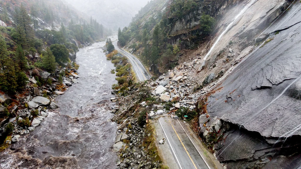
Impact on Northern California
This week’s atmospheric river storm was much stronger in Northern California, where it caused flooding and record rainfall in areas like San Francisco, Sonoma County, and Mendocino County. In Guerneville, the Russian River rose dangerously, flooding nearby areas, and in Mendocino, a home was swept into the river after the hillside gave way. Major highways such as U.S. 101 and California 99 were temporarily closed due to flooding.
Southern California: What to Expect
In Southern California, the impact of this storm is uncertain. The rain could range from light showers to more significant downpours, lasting from six hours to potentially up to two days. One critical factor that could influence the extent of the storm’s effects is how fast the rain falls. If it comes down too quickly, there’s a risk of mudslides and debris flows, particularly in areas recently affected by wildfires.
Meteorologists are also concerned about the possibility of significant rainfall rates, which might lead to dangerous conditions. For example, when rainfall exceeds half an inch per hour, the risk of mudslides increases. While Southern California is not expected to face the same level of disruption as Northern California, residents in burn areas should remain cautious.

Details of the Upcoming Storm
The next atmospheric river storm is expected to reach Southern California late Thursday and last through Friday. The storm will bring light to moderate rain, with some areas possibly experiencing bursts of heavy rain. In particular, Redondo Beach, Long Beach, and Thousand Oaks could see up to half an inch of rain, while Santa Barbara may receive up to 1.25 inches.
Despite the storm’s weak nature, wind gusts will likely affect parts of the state, particularly from Thursday evening to Friday morning. Gusts could reach 40 mph in some areas like San Luis Obispo County and the high deserts of Los Angeles County, though these winds are expected to be milder in urban areas. At Los Angeles International Airport (LAX), the winds could even lead to minor flight delays.
Future Outlook
Although Southern California will likely remain dry for most of the weekend, authorities are keeping a close watch on any potential changes in the weather. If more rain arrives after this week’s storm, it could reduce the fire risk in the region, though the overall wildfire season is not over. Due to the ongoing drought and the region’s moisture deficit, any dry spells could quickly lead to heightened fire danger.
Looking Ahead
While Southern California is seeing some rain relief, the region is still behind in its annual rainfall totals. Downtown Los Angeles, for instance, has only recorded about 0.7 inches of rain since October 1. This is a far cry from the average of 7.68 inches expected during this time of year. If the region experiences another extended dry spell, the fire season could worsen again.

Conclusion
California’s weather is unpredictable right now, with both positive and negative outcomes. While the rain is beneficial for the drought-stricken region, it also comes with its risks, such as potential flooding and landslides. Forecasters continue to monitor the situation closely, advising residents to stay prepared for any sudden weather changes.
Disclaimer – Our editorial team has thoroughly fact-checked this article to ensure its accuracy and eliminate any potential misinformation. We are dedicated to upholding the highest standards of integrity in our content.
More Stories
California Braces for More Record Rainfall and Storms Ahead of Valentine’s Day
California Braces for More Record Rainfall and Storms Ahead of Valentine’s Day
California Braces for More Record Rainfall and Storms Ahead of Valentine’s Day