
HUNTSVILLE, Ala. (WHNT) — The Weather Authority is closely monitoring the situation this week as multiple rounds of rain are expected to impact the region. While the rain will help relieve some of the current drought conditions, the sheer volume of rainfall in a short period could create serious flooding issues.
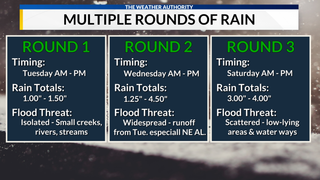
Rain will arrive in three main rounds: Tuesday, Wednesday, and Saturday, and each of these rounds could bring risks of flooding, strong winds, and isolated storms. The most significant flood threat will be on Wednesday and again on Saturday. This is because the ground will already be saturated from the rain that falls earlier in the week. Areas near small creeks, rivers, and streams, which are prone to flooding, will need to be monitored closely.
Strong winds are also expected throughout the week, with gusts reaching 25 mph on Tuesday and Wednesday. These gusts could be strong enough to cause trees to fall. A more powerful weather system is forecast to move in on Saturday, bringing wind gusts of up to 40 mph or possibly even higher.
Tuesday Through Wednesday: The First Round of Rain
The first round of rain will begin Tuesday and last through Wednesday night. A warm front will push northward on Tuesday and stall over the region by midweek. This ongoing flow of moisture, combined with a weather disturbance, will support the development of moderate to heavy rain across the area. By Thursday morning, it is expected that 2 to 5 inches of rain will fall, with areas along and east of I-65 likely to see the highest totals, approaching 5 inches or possibly even more.
The rain will be steady and widespread, and many areas could experience heavy downpours throughout the day and night on Tuesday and Wednesday. As the rain continues, there will be an increased risk of flooding, especially in places that are already vulnerable due to prior rainfall. The ground will be more likely to become saturated, leading to quicker runoff and potential flash flooding.

Saturday: Stronger System Brings Higher Rain and Wind Threats
The second round of rain will arrive on Saturday, and it is expected to be the most powerful of the week. This weather system is forecast to bring not only heavy rainfall but also much stronger wind gusts. Winds could reach 40 mph or more, posing a risk to trees and power lines. This could lead to downed trees and scattered power outages, so it is important to be prepared for potential disruptions.
The rain totals for Saturday could vary depending on where the heaviest rain bands set up, but areas of Northeast Alabama could see nearly 7 inches of rain. In addition, any storms that develop during this round could bring isolated higher rainfall amounts. This means that localized flooding is a significant concern for Saturday, especially in flood-prone areas.
Flooding Concerns Across the Region
Flooding will be the main concern with these rounds of rain, especially in areas where the ground has already absorbed a significant amount of moisture. Streams, rivers, and small creeks are particularly vulnerable to flooding, so officials will be monitoring these closely. With additional rainfall expected throughout the week, it’s important to stay informed and prepared for any changes in flood conditions.
Rain totals for the entire week could vary significantly depending on where the heaviest rainfall occurs. Some areas may see totals closer to 5 inches, while others could experience up to 7 inches or more, depending on the intensity of the rain bands. The potential for isolated storms could further increase the risk of localized flooding, with the possibility of higher rain totals in specific areas.

What You Should Do to Stay Safe
To stay safe during this wet and stormy week, be sure to monitor local weather reports and updates. The Weather Authority will continue to provide the latest forecasts and warnings. If you live in or near flood-prone areas, consider taking precautions to protect your property and ensure your safety. This might include moving vehicles to higher ground, securing outdoor objects that could be blown around by strong winds, and having an emergency kit ready.
Avoid driving through flooded roads, as even small amounts of water can cause vehicles to become stranded or swept away. If you see floodwaters rising near your home, it’s important to evacuate immediately to avoid being trapped.
With three rounds of rain expected over the next week, it’s critical to remain aware of changing weather conditions and be ready to take action if necessary.
Conclusion
As the week progresses, residents in North Alabama will need to stay alert and prepared for heavy rain, strong winds, and the risk of flooding. The Weather Authority will continue to monitor the situation and provide updates as the storm systems move through. Whether you are dealing with the rain or preparing for the potential flooding, it’s important to stay safe, be informed, and follow any weather alerts.

Make sure to follow trusted sources for weather updates and stay prepared throughout the week. Stay safe and watch out for changing conditions as these weather systems move through.
Disclaimer – Our editorial team has thoroughly fact-checked this article to ensure its accuracy and eliminate any potential misinformation. We are dedicated to upholding the highest standards of integrity in our content.
More Stories
Flooding Concerns in Alabama as Heavy Rain and Strong Winds Hit This Week
Flooding Concerns in Alabama as Heavy Rain and Strong Winds Hit This Week
Flooding Concerns in Alabama as Heavy Rain and Strong Winds Hit This Week