

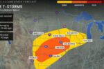
Severe weather returns to Middle Tennessee on Thursday, with most of the region facing a slight risk of severe thunderstorms. Storms are expected to peak between 2 and 10 p.m., according to Samuel Herron, a National Weather Service meteorologist.
According to the weather service, the severe threat should be primarily focused in the afternoon and early evening. Storms will bring damaging winds of up to 60 mph, large hail, and a low chance of tornadoes.
Cooler, more stable weather returns for Friday and the weekend. Temperatures will be in the 50s and 60s Friday through Sunday, with highs in the upper 70s to low 80s on Monday.
The next chance of rain will be on Tuesday, when a cold front approaches from the north, according to the weather service.

Nashville’s 7-day forecast
Wednesday: Sunny, with a high near 68 and a low around 51 at night, with a 30% chance of rain.
Thursday: Mostly sunny, with a high around 72 and a 70% chance of showers and thunderstorms. Storms are likely to continue after 4 p.m. Then partly cloudy with a low of 46 degrees and a 60% chance of showers and thunderstorms before 10 p.m. Storms are likely to last until 1 a.m.
Friday: Partly sunny, with a high around 58 and a 30% chance of showers, primarily after 1 p.m. Then, partly cloudy with a low of 39 at night.

Saturday: Sunny, with a high about 62 and a low of around 40 at night.
Sunday: Sunny, with a high around 71 and a low around 54 at night.
Monday: Mostly sunny, with a high near 82 and a low around 57 at night, with a 20% chance of rain and thunderstorms.
Tuesday: Partly sunny, with a high around 73 and a 20% chance of showers.
More Stories
Severe Thunderstorms Expected Thursday in Middle Tennessee, Followed by Cooler Weekend
Severe Thunderstorms Expected Thursday in Middle Tennessee, Followed by Cooler Weekend
Severe Thunderstorms Expected Thursday in Middle Tennessee, Followed by Cooler Weekend